

Population distribution and local spatial dependence
The settlement of people in the territory responds to their personal and contextual preferences and it is based on the close relationships offered by the environment beyond the residential area. The study here presented has analyzed this issue through a Massachusetts-centered empirical case study throught which the researchers have established which elements influence the choice of location and how this predisposition impacts society.
Does proximity truly matter in decisions about location? Individual choices of location often depend upon a neighborhood’s attractiveness in any number of its various dimensions, including access to services for everyday life, natural parks, open-air leisure spaces, and other amenities. However, individuals are also often concerned about the reputations of places in which they may settle. They may also care about the ethnic composition of the neighborhoods, as well as the average level of income and education among residents.
Although all of those variables shape location preferences, the formation of such preferences not only depends upon selected determinants at each spatial unit as a self-contained space. But, it spreads across units and spatial proximity reinforces its cross-fertilizing effects. Thus, an individual may prefer to live in a high-income district, though the decision to settle there is likely associated, at least to some degree, with the income level of people living in districts closer to it
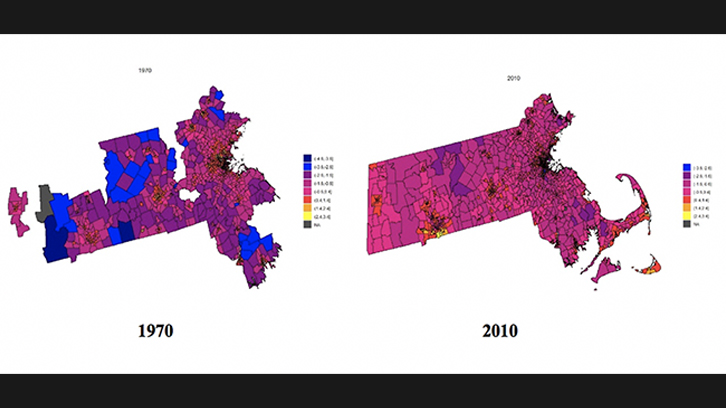
This study explores, from an empirical perspective, the way in which spatial dependence contributes to shaping population density distribution. Our analysis is performed with data at the census-tract level for Massachusetts from 1970 to 2010. An important added value of our analysis is the introduction of a novel way of modeling spatial dependence. We associate spatial dependence with spatial proximity on a small scale in order to grasp the dimension that favors efficient, direct interactions among individuals belonging to close spatial units—in our case, census tracts. In modeling that type of interaction among economic agents, we refer heavily to network models for ecological data that embed the idea of connectivity among agents.
A first set of results confirm well-known findings in the literature: income and ethnic composition are key determinants for identifying the reputation of a neighborhood and, hence, they heavily influence individuals’ location choices. In this sense, our predictions confirm that segregation effects exacerbated in Massachusetts. Nevertheless, our principal result is being able to assess the rise of the importance of spatial dependence (via spatial proximity) over time. It means that at the beginning of our period of analysis, location decisions were mostly related to exclusive individual features of the spatial units whereas at the end of the period the importance of environmental conditions beyond borders’ units were becoming more and more relevant over time.
Our interpretation of these results goes jointly with the appreciation of the technological revolution that our society is experiencing. New technologies reduce communication distances and, to some extent, spatial distance as well such to favor individual-based contacts. Under this perspective, our outcomes confirm that the reorganization of the land structure is a reaction to those types of changes. In this wake, individual location preferences turn to be based on individual priorities and environmental conditions and, we are able to quantify the indirect effects of other individuals’ choices.
Àrea d'Economia Aplicada
Universitat Autònoma de Barcelona
References
Ilenia Epifani, Chiara Ghiringhelli & Rosella Nicolini (2020). Population distribution over time: modelling local spatial dependence with a CAR process, Spatial Economic Analysis, 15:2, 120-144, DOI: 10.1080/17421772.2020.1708442